A dedicated team of storm chasers, operating under the banner of the OTUS Project (Observations of Tornadoes by UAV Systems), is pushing the boundaries of meteorological science by deploying specially designed camera drones directly into the heart of active tornadoes. This groundbreaking initiative has successfully executed over a dozen tornado intercepts, culminating in a historic live-streamed penetration of an EF3 tornado in June, offering the world a never-before-seen perspective from within the powerful vortex.
Pioneering Inside the Storm
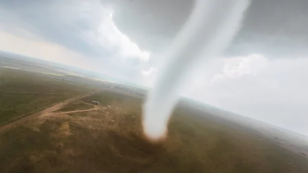
The OTUS Project’s audacious endeavor involves piloting purpose-built drones into wind speeds exceeding 100 miles per hour. These unmanned aerial vehicles are meticulously engineered to gather crucial surface-level atmospheric data—temperature, moisture content, and wind velocity—that is exceptionally difficult, if not impossible, to obtain through conventional methods. Simultaneously, the drones provide a visceral, first-person view from inside the tornado’s funnel, an experience described by those who have witnessed it as profoundly compelling and almost unbelievable. One such remarkable intercept, captured near Arnett, Oklahoma, offers a stark illustration of the raw power and dynamic forces at play within these destructive weather phenomena.
The visual evidence from these missions is nothing short of astonishing. A video segment from an intercept near Arnett, Oklahoma, showcases the chaotic yet scientifically invaluable footage obtained by the OTUS Project drones. This footage allows researchers and the public alike to witness the swirling debris, the intense updrafts, and the sheer force that defines a tornado’s core, all from an intimate, aerial vantage point. The implications for understanding tornado dynamics are immense, offering a direct observational window into processes that have historically been inferred from damage patterns and limited ground-based measurements.
Engineering Resilience for Extreme Conditions
The drones deployed by the OTUS Project are not commercially available off-the-shelf units. Instead, they are custom-built machines designed and constructed from the ground up to withstand the extreme conditions within a tornado. Louis Tucker, a former National Collegiate Drone Racing Champion (2023), leads the team’s fabrication efforts, bringing his expertise in high-performance drone design. He is complemented by engineer Tanner Beard, who utilizes a sophisticated array of tools in his home workshop, including a mill, lathe, welder, and multiple 3D printers, to machine and create the specialized components.
The airframes themselves are 3D-printed, contributing to their remarkably light weight of approximately two pounds. This lightweight design, coupled with a top speed of 220 miles per hour, is critical. It allows the drones to maintain their integrity and penetrate the intense debris fields and formidable vertical wind loads characteristic of tornadoes, rather than being instantly incapacitated or swatted out of the sky. Each drone is equipped with a high-definition GoPro camera to capture visual data and a suite of advanced sensors. These sensors continuously log temperature, humidity, barometric pressure, and three-dimensional wind loads. The OTUS Project maintains a fleet of approximately 15 such aircraft, with individual drones costing around $2,500. The team estimates their personal investment in this ambitious project has surpassed $25,000 in a single year, underscoring their deep commitment to this scientific pursuit.
The Genesis of an Unprecedented Instrument
The necessity for custom-built instruments stems from the fact that the OTUS Project is essentially inventing the technology required for their mission. A key innovation has been the development of an omnidirectional wind sensor, a project undertaken in collaboration with the National Institute of Standards and Technology (NIST). Nelson Tucker, a key member of the team, spearheaded the development of this sensor, which is capable of accurately measuring the critical vertical wind component within a tornado. This specific measurement is a significant challenge for ground-based instruments and has historically been a blind spot in tornado research. The requirement for such a sensor to be light enough for aerial deployment necessitated this bespoke engineering solution.
The flight protocol employed by the OTUS Project is as deliberate as their engineering. Drones are initially maneuvered to orbit the tornado funnel at various altitudes. This allows for data collection from different atmospheric layers and provides a broader understanding of the storm’s structure. As the opportunity arises and conditions permit, the drones gradually tighten their orbital paths, eventually crossing into the tornado’s vortex to gather direct measurements and unparalleled visual data from within. This methodical approach maximizes the scientific return while attempting to mitigate the inherent risks.
Science and Safety: The Dual Imperative
While the visual spectacle of drones venturing into the heart of a tornado is undoubtedly attention-grabbing, the core mission of the OTUS Project is firmly rooted in advancing scientific understanding and improving public safety. The unprecedented volume and detail of data collected from within a tornado’s core have the potential to significantly enhance the accuracy and lead time of tornado warnings. By providing a clearer picture of the forces and atmospheric conditions that define these storms, scientists can refine predictive models and better anticipate tornado behavior. This, in turn, can translate into crucial extra minutes for communities to seek shelter, potentially saving lives and reducing injuries.
Furthermore, for individuals and organizations involved in aerial videography and drone technology, the OTUS Project’s achievements represent a staggering testament to the evolving capabilities of small drones. The imagery captured, offering a first-person perspective from within a tornado, would have been considered pure science fiction just a few years ago. This technological leap underscores the rapid advancements in drone design, miniaturization of sensors, and sophisticated piloting techniques, opening new frontiers for exploration and data acquisition in a wide range of challenging environments.
Historical Context and Future Implications
The study of tornadoes has a long and often perilous history. Early attempts to understand these phenomena involved direct observation from a safe distance, often leading to speculation rather than precise data. As technology advanced, Doppler radar provided invaluable insights into the internal wind structure of storms, but direct measurement within the tornado itself remained elusive. Ground-based instruments, while useful, are limited by their inability to capture the full three-dimensional dynamics, particularly the powerful updrafts.
The OTUS Project’s work builds upon decades of storm chasing and meteorological research. Their innovative approach represents a paradigm shift, moving from indirect observation to direct, in-situ data collection within the most extreme weather events. The development of lightweight, robust sensors capable of surviving such conditions is a significant scientific and engineering achievement.
The success of the OTUS Project also raises important questions and considerations regarding the future of atmospheric research. The ability to deploy drones into hazardous environments could revolutionize data collection not only for tornadoes but also for hurricanes, wildfires, and volcanic eruptions. This could lead to more comprehensive datasets, improved forecasting models, and a deeper understanding of Earth’s most dynamic processes.
However, this advancement also brings ethical and practical considerations. The significant personal investment by the team highlights the need for potential future funding and institutional support to sustain and expand such critical research. Ensuring the safe and responsible deployment of this technology will also be paramount.
Official Reactions and Broader Impact
While specific official statements from meteorological organizations regarding the OTUS Project were not immediately available for this report, the general scientific community widely acknowledges the importance of direct, high-resolution data from within extreme weather events. Agencies like the National Oceanic and Atmospheric Administration (NOAA) and the National Weather Service (NWS) continuously seek to improve their understanding of severe weather phenomena to enhance warning systems. The data generated by the OTUS Project is likely to be of immense interest to these bodies, potentially informing future research initiatives and technological development in storm observation.
The broader impact of the OTUS Project extends beyond the scientific realm. Their work captures the human spirit of innovation and perseverance in the face of immense challenges. It demonstrates how passionate individuals, armed with cutting-edge technology and a clear scientific objective, can achieve remarkable feats that push the boundaries of what we thought possible. The live-streamed events, in particular, have the potential to inspire a new generation of scientists and engineers, showcasing the thrill and profound importance of scientific exploration.
In conclusion, the OTUS Project stands as a pioneering force in meteorological research, employing innovative drone technology to gather unprecedented data from within active tornadoes. Their work not only promises to enhance our understanding of these destructive forces but also exemplifies the relentless pursuit of knowledge and the transformative power of human ingenuity in the face of nature’s most formidable challenges. The data collected will undoubtedly contribute to more robust weather models, leading to improved warning systems and ultimately, greater safety for communities worldwide.