
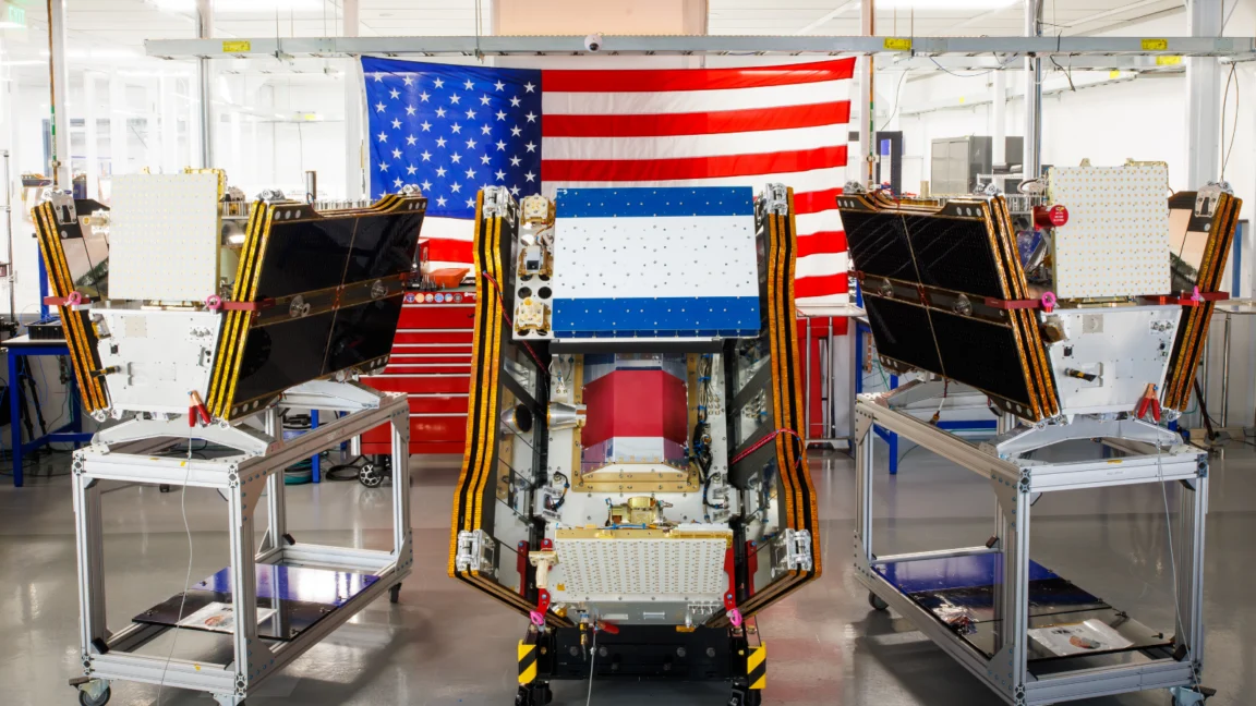
As vast plumes of smoke from hundreds of raging wildfires continue to blanket regions across Canada and the United States, casting a pall over millions and causing widespread hazardous air pollution, the FireSat program has achieved a significant milestone with the successful launch of its first three operational satellites. These cutting-edge microsatellites, backed by Google and other major philanthropic organizations, are poised to revolutionize wildfire detection, offering the ability to spot even nascent blazes in critical fire-prone areas across the United States, Australia, and Europe before the end of the year.
The launch, executed on July 7, 2026, aboard a SpaceX Falcon 9 rocket from Vandenberg Space Force Base in California, signifies a pivotal transition to "initial operational capability" for the FireSat constellation. This ambitious initiative is managed by the nonprofit Earth Fire Alliance, a consortium dedicated to addressing the escalating global wildfire challenge. Following a rigorous three-month testing phase, these initial satellites will commence actively transmitting crucial data to fire agencies worldwide, ensuring that every fire-prone region on Earth receives coverage at least twice daily. This marks a critical advancement in an era where traditional detection methods are increasingly overwhelmed by the scale and intensity of wildfires.
A New Era in Wildfire Detection Technology
The FireSat constellation stands apart as the first satellite system purpose-built exclusively for wildfire detection. Unlike existing general-purpose Earth observation satellites, FireSat is engineered to identify smaller fires that often escape the notice of other systems, enabling earlier intervention that can dramatically alter a blaze’s trajectory. The satellites, meticulously designed and manufactured by California-based Muon Space, boast multispectral imaging capabilities that allow them to penetrate dense smoke and cloud cover, detecting fires as small as five by five meters (approximately 16 by 16 feet). This high-resolution detection capacity is critical for identifying fires in their earliest, most manageable stages.
The efficacy of this technology was unequivocally demonstrated by a FireSat Protoflight satellite, which launched in March 2025. This precursor mission collected over one million images, proving its ability to detect low-intensity blazes that remained invisible to conventional satellite systems. This successful validation paved the way for the full operational deployment now underway.
The FireSat program has garnered substantial financial support from prominent organizations, underscoring the urgent global need for advanced wildfire solutions. Google has committed over $15 million towards the initial deployment, recognizing the transformative potential of this technology. Further significant backing has come from the Bezos Earth Fund, which pledged an additional $26 million, highlighting a shared commitment among tech giants and philanthropic entities to leverage innovation for climate resilience.

Projected Impact and Phased Rollout
The Earth Fire Alliance projects that even an hourly revisit rate from the FireSat constellation could yield profound benefits. Their analysis suggests that such timely detection could help save more than $1 billion in fire damage costs annually, prevent nearly 22 million tons of carbon emissions, and protect approximately 3,500 homes and 1.3 million acres of land. These figures underscore the potential for FireSat to deliver tangible environmental and economic relief from the devastating impacts of wildfires.
A diverse cohort of "early adopter" organizations has already been identified to begin utilizing FireSat data later this year. These include vital fire agencies in California, Colorado, Australia, and Portugal, signifying the global reach and applicability of the program. As additional satellites are launched and integrated into the constellation, the FireSat program aims to provide the latest imagery anywhere in the world on an hourly basis by 2029. The ultimate vision is to achieve a remarkable 20-minute revisit rate once the full constellation, comprising more than 50 satellites, is fully deployed by the early 2030s.
Google Research is playing a crucial role in maximizing FireSat’s utility. The company plans to deploy its advanced AI models to analyze operational FireSat data, comparing it with historical images to accurately identify even minute fires and to feed into sophisticated predictive modeling of wildfire behavior. This integration of artificial intelligence is central to Google’s stated mission of "putting practical AI to work for climate resilience," a sentiment expressed by the company in celebrating the launch of the first operational FireSat satellites.
The Escalating Global Wildfire Crisis and Its Roots
The urgency behind initiatives like FireSat is rooted in a rapidly escalating global wildfire crisis, inextricably linked to the broader challenges of climate change. This summer’s wildfires in Canada’s vast boreal forests serve as a stark reminder of this intensifying threat. These blazes have forced thousands of people, particularly those in vulnerable First Nations communities, to evacuate their homes, disrupting livelihoods and cultural heritage. The resulting smoke has traveled thousands of miles, inflicting hazardous air pollution upon over 100 million people across major Canadian and US cities, including communities in the Midwest, Mid-Atlantic, and Northeast.
Scientific consensus overwhelmingly attributes the increasing size and intensity of these wildfires to global warming, driven primarily by anthropogenic greenhouse gas emissions from the burning of fossil fuels. Canada, in particular, has experienced two of its most destructive wildfire seasons in 2023 and 2025, with the last three fire seasons ranking among the top ten worst on record. This trend points to a systemic shift in wildfire behavior, presenting unprecedented challenges for land managers and emergency responders.

Werner Kurz, a retired senior research scientist at Natural Resources Canada, articulated the gravity of the situation to The Atlantic, stating, "What is unfolding is what climate and forest scientists have been predicting for 30 years—that as the world gets hotter and drier, we are exposing forests to more and more risk, and the old strategies of fire suppression are simply being overwhelmed." His remarks underscore the inadequacy of traditional fire management approaches in the face of a rapidly changing climate.
Fighting wildfires, especially in remote, uninhabited forest regions, demands an immense deployment of resources. This includes specialized fixed-wing air tankers and heavy-lift helicopters capable of dropping fire retardants or rapidly transporting firefighting crews to inaccessible sites. However, the burden of acquiring and contracting for such vital firefighting aircraft typically falls upon individual Canadian provinces, leading to resource strains. In recent years, every available aircraft has often been pressed into service, highlighting a systemic capacity deficit. Recognizing this challenge, the Canadian government has recently leased 10 new aerial firefighting aircraft to serve as surge assets for provinces, bolstering nationwide response capacity.
As of July 17, the Canadian Wildland Fire Information System reported nearly 900 active wildfires across the country, with over 3,600 fires recorded to date, burning more than 6.6 million acres. Critically, dozens of these are classified as "out of control" and are merely being monitored rather than actively suppressed. This grim reality reflects the difficult decisions fire agencies are forced to make when confronted with limited resources and the paramount need to ensure the safety of firefighting personnel.
The Dual Impact of Technology: AI’s Carbon Footprint
While FireSat represents a beacon of technological hope in the fight against climate change, it also brings into focus a critical paradox: the burgeoning environmental footprint of the very technologies designed to address climate issues. Silicon Valley’s accelerated deployment of advanced AI models, while yielding solutions like FireSat, comes with considerable climate costs, particularly through the energy demands of massive AI data centers.
These data centers require enormous amounts of electricity, which, in the United States, are frequently sourced from new natural gas projects. The collective greenhouse gas emissions from this expanding data center infrastructure could potentially exceed 129 million tons annually. Google, a leading proponent of AI development and a key backer of FireSat, has openly acknowledged the formidable challenges of deploying sufficient clean energy projects to offset the potential emissions from its energy-hungry data centers. The company’s own electricity usage, driven by its AI buildout, experienced a substantial 37 percent increase in 2025 alone, illustrating the scale of this environmental challenge.
This creates a complex narrative where technological advancements aimed at mitigating climate crises are simultaneously contributing to the problem through their energy demands. The ethical and practical implications of this dual impact are increasingly becoming a subject of public and scientific scrutiny.

Beyond Detection: A Holistic Approach to Wildfire Management
The financial and technical support provided by Google and others to AI-powered wildfire detection programs like FireSat is undeniably valuable and could prove incredibly helpful in early response efforts. However, wildfire detection, no matter how sophisticated, is but one component of a multi-faceted strategy required to prevent blazes from spiraling out of control.
Effective wildfire management necessitates a holistic approach that extends far beyond early detection. Fire agencies require adequate resources—including personnel, equipment, and sustained funding—to manage ecosystems proactively through practices such as prescribed burns and strategic forest thinning. These preventative measures are crucial for reducing fuel loads and creating more resilient landscapes. Furthermore, sufficient capacity is needed to rapidly and effectively suppress unwanted fires once they ignite. The escalating challenges posed by global warming only amplify the difficulty of these tasks.
Therefore, while FireSat promises to deliver an unprecedented level of awareness regarding nascent wildfires, it must be viewed as an essential tool within a broader framework of climate adaptation and mitigation. This framework must encompass robust environmental policies, sustained investment in both preventative measures and response capabilities, and a global commitment to reducing the underlying drivers of climate change. Without such an integrated strategy, even the most advanced technological solutions will struggle to contain the growing threat of wildfires in a warming world. The ongoing battle against wildfires demands not just innovation, but also comprehensive resource allocation and a fundamental shift in how humanity interacts with its environment.