
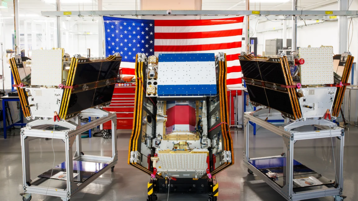
As smoke from hundreds of raging wildfires continued to blanket vast swathes of Canada and the United States, casting a pall over major cities and impacting the health of millions, a significant leap forward in wildfire management was achieved with the successful launch of the first three operational satellites in the Google-backed FireSat program. Blasting into orbit aboard a SpaceX Falcon 9 rocket from Vandenberg Space Force Base in California on July 7, 2026, these microsatellites mark a pivotal transition to "initial operational capability" for the FireSat constellation, managed by the non-profit Earth Fire Alliance. Following a crucial three-month testing period, these advanced sentinels are poised to begin actively providing critical wildfire detection data to fire agencies across the United States, Australia, and Europe before the year’s end, promising to spot nascent blazes that current systems often overlook.
A New Frontier in Early Wildfire Detection
The FireSat program represents a paradigm shift in global wildfire surveillance, being the first satellite constellation meticulously engineered from the ground up specifically for detecting wildfires. Its core innovation lies in its capacity to identify even small fires, down to a remarkable five by five meters (approximately 16 by 16 feet), a capability that significantly outpaces existing satellite systems. This precision is made possible by sophisticated multispectral imaging technology integrated into each satellite, allowing them to penetrate dense smoke and cloud cover – conditions that frequently obscure fires from conventional observation methods.
The efficacy of this groundbreaking technology was unequivocally demonstrated by a FireSat Protoflight satellite, which was launched in March 2025. During its mission, this prototype collected over one million images, proving its ability to detect low-intensity blazes that remained invisible to other satellites in orbit. This successful validation paved the way for the deployment of the operational constellation, signaling a new era in proactive wildfire management. The Earth Fire Alliance, the driving force behind the constellation, asserts that once fully operational, these satellites will cover every fire-prone region on Earth at least twice daily, a frequency designed to dramatically reduce response times and mitigate the destructive potential of rapidly spreading fires.
Collaborative Funding and Global Ambitions
The FireSat initiative is a testament to the power of collaborative innovation, drawing substantial financial and technical support from leading philanthropic organizations and technology giants. California-based satellite manufacturer Muon Space designed and built the microsatellites, bringing their expertise in advanced aerospace engineering to the project. Google has been a significant early investor, committing over $15 million to support the initial deployment phases of the constellation. This investment aligns with Google’s broader commitment to leveraging artificial intelligence and technological innovation for climate resilience, as articulated by their research division.

Beyond Google, the Bezos Earth Fund has also emerged as a critical financial backer, pledging an impressive $26 million to the endeavor. This substantial commitment underscores a growing recognition among major philanthropic entities of the urgent need for scalable solutions to combat the escalating global wildfire crisis. "The devastating impact of wildfires on communities, ecosystems, and global climate stability demands innovative responses," stated a spokesperson for the Bezos Earth Fund, emphasizing their belief in FireSat’s potential to deliver actionable intelligence that can save lives and protect natural resources. The Earth Fire Alliance, as the orchestrating non-profit, plays a crucial role in managing the constellation and ensuring its data is effectively disseminated to fire agencies worldwide.
The initial rollout will see FireSat data adopted by "early adopter" organizations, including fire agencies in high-risk regions such as California and Colorado in the United States, as well as agencies in Australia and Portugal. These regions have consistently grappled with severe wildfire seasons, making them ideal proving grounds for the new technology. As the constellation expands, the FireSat program envisions a future where the latest imagery is available anywhere in the world on an hourly basis by 2029. The ultimate goal, projected for the early 2030s, is to deploy a full constellation of more than 50 satellites, capable of providing imagery every 20 minutes, offering near real-time intelligence for fire managers.
The Economic and Environmental Dividends of Early Detection
The potential benefits of FireSat’s enhanced detection capabilities are profound, extending across economic, environmental, and humanitarian spheres. The Earth Fire Alliance has published compelling projections, suggesting that even an hourly revisit rate from the FireSat constellation could lead to substantial savings. Their analysis indicates the potential to save over $1 billion in fire damage costs annually. This figure encompasses not only the direct costs of property loss and infrastructure damage but also the indirect economic impacts on tourism, agriculture, and local economies.
Beyond financial implications, the environmental dividends are equally significant. Early detection and rapid suppression can prevent nearly 22 million tons of carbon emissions, a crucial contribution to global efforts to combat climate change. Wildfires are major contributors to atmospheric carbon, and reducing their intensity and spread directly lessens this impact. Furthermore, the alliance estimates that FireSat could help protect 3,500 homes and safeguard 1.3 million acres of land annually, preserving biodiversity, critical habitats, and the livelihoods of communities reliant on these ecosystems.
Google Research plans to integrate the operational FireSat data with its powerful AI models. This synergy will enable sophisticated comparative analysis with historical images, allowing for the accurate identification of very small fires and informing predictive modeling of wildfire behavior. This AI-driven approach is expected to enhance the system’s ability to not only detect fires but also forecast their potential spread and intensity, offering an invaluable tool for strategic resource deployment. Celebrating the launch, Google emphasized its commitment to "putting practical AI to work for climate resilience," highlighting the critical role technology can play in addressing some of the planet’s most pressing environmental challenges.
The Escalating Global Wildfire Crisis and the Climate Connection

The launch of FireSat unfolds against a backdrop of an increasingly severe and widespread global wildfire crisis, a direct consequence of a warming planet. The summer of 2026 has witnessed unprecedented wildfire activity, particularly across Canada’s boreal forests, which have been ablaze for months. These fires have forced thousands of people, including numerous First Nations communities, to evacuate their homes, disrupting lives and causing immense hardship. The smoke plumes from these infernos have traveled thousands of miles, blanketing Canadian and US cities in hazardous air pollution, affecting the health of over 100 million people across the Midwest, Mid-Atlantic, and Northeast regions.
Scientists and climate experts have long warned of this escalating crisis. Werner Kurz, a retired senior research scientist at Natural Resources Canada, encapsulated the grim reality: "What is unfolding is what climate and forest scientists have been predicting for 30 years. That as the world gets hotter and drier, we are exposing forests to more and more risk, and the old strategies of fire suppression are simply being overwhelmed." Canada, in particular, has experienced two of its most destructive wildfire seasons in 2023 and 2025, with the last three fire seasons consistently ranking among the ten worst on record. This trend is not unique to Canada, with regions globally, from the Amazon to Australia, facing similar challenges.
The fundamental driver behind this intensification is climate change, fueled by greenhouse gas emissions from human reliance on fossil fuels. Warmer temperatures, prolonged droughts, and altered precipitation patterns create ideal conditions for fires to ignite and spread with unprecedented speed and ferocity. The Canadian Wildland Fire Information System reported nearly 900 active wildfires across the country as of July 17, 2026, with over 3,600 wildfires having burned more than 6.6 million acres to date this year alone. Disturbingly, dozens of these are classified as "out of control" wildland fires, which fire agencies are forced to merely monitor rather than actively suppress. This agonizing decision highlights the severe limitations of current resources when faced with overwhelming numbers and the paramount need to prioritize firefighter safety.
Traditional fire suppression methods, particularly in vast and often uninhabited boreal forest regions, have proven increasingly inadequate. These efforts heavily rely on specialized assets such as fixed-wing air tankers capable of dropping fire retardants and heavy-lift helicopters for water bombing and transporting firefighting crews to remote sites. However, the burden of acquiring and contracting for such expensive aircraft typically falls upon individual Canadian provinces, leading to fragmented and often insufficient resources. In recent years, every available aircraft has frequently been pressed into service, stretching capabilities to their breaking point. Recognizing this critical gap, the Canadian government took a significant step in May 2026, leasing 10 new aerial firefighting aircraft to serve as surge assets for provinces, aiming to bolster nationwide response capacity. While commendable, such measures are often reactive and struggle to keep pace with the accelerating scale of the problem.
The AI Paradox: Innovation Amidst Energy Demands
While FireSat represents a beacon of technological hope in the fight against wildfires, its development and the broader Silicon Valley rush to deploy new AI models also raise critical questions about their environmental footprint. The burgeoning demand for larger and more powerful AI data centers requires massive amounts of electricity, a demand that is increasingly being met by new natural gas projects in the United States. Analysts project that greenhouse gas emissions from this data center boom could collectively exceed 129 million tons per year, potentially outpacing the total emissions of entire nations.
Google itself has acknowledged the significant challenges in deploying enough clean energy projects to offset the potential emissions from its energy-hungry data centers. The company’s own electricity usage surged by 37 percent in 2025, largely driven by its intensive AI buildout. This presents a complex paradox: while Google financially and technically supports AI-powered solutions for climate resilience, the very infrastructure underpinning these solutions contributes to the climate change problem they aim to solve. This duality necessitates a holistic approach to sustainability, where technological advancements are not only designed to mitigate climate impacts but are also developed and operated with a minimal environmental footprint.

A Multi-Faceted Challenge Requiring Comprehensive Solutions
The FireSat program offers a powerful new tool in the arsenal against wildfires, providing unprecedented capabilities for early detection and crucial data for strategic management. Its launch is undoubtedly a tangible step forward in leveraging cutting-edge technology for climate resilience. However, wildfire detection, no matter how advanced, is just one component of a much larger, multi-faceted challenge. Effective wildfire management requires a comprehensive approach that extends far beyond early warning systems.
Fire agencies globally require sufficient resources for active suppression, including personnel, equipment, and aerial assets, to respond swiftly to detected blazes. Equally vital are proactive measures, such as prescribed burns, forest thinning, and other ecosystem management strategies that reduce fuel loads and promote forest health. These preventative actions are crucial in creating more resilient landscapes less prone to catastrophic fires. As global warming continues to intensify, making landscapes hotter and drier, the job of fire agencies becomes exponentially more challenging. The promise of FireSat lies not just in its ability to see through the smoke, but in its potential to empower fire managers with the timely intelligence needed to act decisively, integrate with broader land management strategies, and ultimately, build a more resilient future against the increasing threat of wildfires.
Jeremy Hsu is a reporter exploring a wide range of topics across deep tech and AI. He has previously written for New Scientist, Scientific American, IEEE Spectrum, Wired, Undark Magazine and MIT Tech Review, among many other publications, about topics such as deepfakes, data centers, drones, battery tech, robotics, and GPS jamming. He also has a Master of Arts in Journalism from NYU, and a bachelor’s degree from University of Pennsylvania in History and Sociology of Science, with a minor in English.