
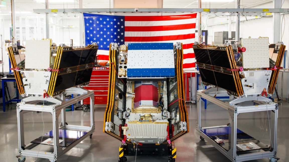
As vast plumes of smoke from hundreds of raging wildfires continued to blanket large swathes of Canada and the United States, casting a pall over urban centers and rural communities alike, the inaugural trio of operational satellites in the groundbreaking FireSat program successfully achieved orbit. This pivotal launch marks a significant leap forward in global wildfire management, with these advanced microsatellites poised to deliver unparalleled detection capabilities, capable of identifying even nascent fires across the United States, Australia, and Europe before the close of the current year.
A New Era in Wildfire Surveillance Takes Flight
The deployment of these crucial satellites occurred on July 7, 2026, when a SpaceX Falcon 9 rocket roared to life from Vandenberg Space Force Base in California. This mission signifies the transition to "initial operational capability" for the FireSat constellation, an ambitious initiative spearheaded by the nonprofit Earth Fire Alliance. Following an intensive three-month calibration and testing phase, these three pioneering satellites will commence active data provision to fire management agencies worldwide, ensuring coverage of every fire-prone region on Earth at least twice daily. This regular surveillance promises to revolutionize early detection, a critical factor in preventing small blazes from escalating into catastrophic infernos.
The FireSat constellation stands alone as the first satellite network explicitly engineered for wildfire detection. Its design prioritizes the identification of smaller fires, a capability often beyond the reach of conventional Earth-observing satellites. California-based satellite manufacturer Muon Space developed these cutting-edge microsatellites, benefiting from substantial financial backing, including over $15 million from Google. Further reinforcing the program’s robust support, the Bezos Earth Fund contributed a significant $26 million, underscoring the broad philanthropic and technological commitment to addressing the escalating global wildfire crisis.
Each FireSat satellite is equipped with sophisticated multispectral imaging technology, allowing it to penetrate dense smoke and cloud cover. This advanced capability enables the detection of fires as small as five by five meters—approximately 16 by 16 feet—a resolution previously unattainable by many existing systems. The efficacy of this technology was conclusively demonstrated by a FireSat Protoflight satellite, which launched in March 2025. During its mission, the Protoflight collected over one million images, proving its capacity to identify low-intensity blazes that were imperceptible to other satellites in orbit, thereby validating the core premise of the FireSat program.
The Urgent Need for Advanced Detection

The increasing frequency and intensity of wildfires represent one of the most pressing environmental challenges of the 21st century. Climate change, driven by anthropogenic greenhouse gas emissions, has exacerbated conditions, leading to longer and hotter dry seasons, increased fuel availability, and more extreme weather patterns conducive to rapid fire spread. The consequences are far-reaching, encompassing devastating economic losses, extensive ecological damage, severe public health impacts from smoke pollution, and significant contributions to atmospheric carbon, further accelerating global warming in a dangerous feedback loop.
According to a 2023 report by the UN Environment Programme (UNEP), the number of extreme wildfires is projected to increase by 14% by 2030, 30% by 2050, and 50% by the end of the century. The economic toll is staggering, with global wildfire damages estimated to be in the tens of billions of dollars annually, excluding the incalculable costs of human lives lost, mental health trauma, and biodiversity destruction. For instance, the 2019-2020 Australian bushfire season, dubbed "Black Summer," burned over 46 million acres, destroyed thousands of homes, and resulted in an estimated three billion animals killed or displaced, with economic costs exceeding A$100 billion. Similarly, California has experienced a dramatic increase in megafires, with the state’s eight largest wildfires on record all occurring since 2017.
FireSat’s Phased Rollout and Ambitious Goals
The initial phase of FireSat’s operational deployment targets regions most susceptible to immediate and devastating wildfire impacts. "Early adopter" organizations, including fire agencies in California, Colorado, Australia, and Portugal, are slated to begin integrating FireSat data into their operations later this year. These partnerships are crucial for refining data delivery mechanisms and optimizing the utility of the satellite imagery for on-the-ground firefighting efforts.
The program’s ambitions extend far beyond its initial deployment. By 2029, as more satellites join the constellation, FireSat aims to provide the latest imagery from any location on Earth on an hourly basis. This significantly improved revisit rate will drastically reduce the time between a fire’s ignition and its detection, enabling faster deployment of suppression resources. Looking further ahead, the ultimate goal is to launch a full constellation of more than 50 satellites by the early 2030s, which would achieve an unprecedented 20-minute revisit rate. Such frequent updates would provide near real-time intelligence, giving firefighters a critical advantage in combating blazes before they grow uncontrollably.
The Earth Fire Alliance projects that even an hourly revisit rate from the FireSat constellation could yield substantial benefits, including saving over $1 billion in fire damage costs, preventing nearly 22 million tons of carbon emissions, and protecting an estimated 3,500 homes and 1.3 million acres of land annually. These projections underscore the immense potential of early detection as a cornerstone of modern wildfire management strategies.
Google’s AI Integration and the Ethical Dilemma of Computational Power

Google’s involvement extends beyond financial contributions. Google Research is leveraging the company’s powerful AI models to maximize the utility of FireSat data. These models are designed to compare real-time operational FireSat data with historical imagery, allowing for the accurate identification of even minute fires. Furthermore, this AI integration will inform sophisticated predictive modeling of wildfire behavior, helping agencies anticipate fire paths and allocate resources more effectively. Google celebrated the launch of the first operational FireSat satellites as "another tangible step forward in putting practical AI to work for climate resilience," highlighting the company’s commitment to applying its technological prowess to urgent global challenges.
However, the rapid proliferation of advanced AI models, while offering promising solutions like FireSat, also presents a significant environmental paradox. The immense computational power required to train and operate these complex AI systems demands colossal amounts of electricity. This demand often drives the construction of new energy infrastructure, frequently relying on fossil fuels. In the United States, the burgeoning AI data center industry is projected to contribute to greenhouse gas emissions exceeding 129 million tons annually, potentially surpassing the total emissions of entire nations.
Google itself has openly acknowledged the challenges inherent in sourcing sufficient clean energy to offset the burgeoning emissions from its energy-hungry data centers. The company reported a 37 percent increase in its company-wide electricity usage in 2025, directly attributable to its aggressive AI buildout. This creates a complex ethical and practical dilemma: while AI offers powerful tools for climate action, its own carbon footprint necessitates urgent attention and innovative solutions to ensure that the technology itself does not inadvertently worsen the crisis it seeks to mitigate. The development of more energy-efficient AI algorithms, coupled with aggressive investment in renewable energy infrastructure for data centers, remains a critical imperative.
The Canadian Wildfire Crisis: A Stark Reminder
The urgency of FireSat’s mission is underscored by the devastating wildfire season currently engulfing Canada’s boreal forests. As of July 2026, these fires have forced thousands of people, particularly from First Nations communities, to evacuate their homes, disrupting lives and threatening cultural heritage. The smoke generated by these blazes has drifted south, blanketing major Canadian and US cities in a choking haze and exposing over 100 million people to hazardous air pollution.
This unfolding catastrophe is precisely what climate and forest scientists have warned about for decades. Werner Kurz, a retired senior research scientist at Natural Resources Canada, articulated this grim reality to The Atlantic, stating, "What is unfolding is what climate and forest scientists have been predicting for 30 years—that as the world gets hotter and drier, we are exposing forests to more and more risk, and the old strategies of fire suppression are simply being overwhelmed." Canada has experienced two of its most destructive wildfire seasons in 2023 and 2025, with the last three fire seasons ranking among the ten worst on record, a clear indication of a shifting climate paradigm.
Fighting wildfires in vast, often uninhabited boreal forest regions presents unique logistical challenges. It necessitates specialized resources such as fixed-wing air tankers capable of dropping fire retardants and heavy-lift helicopters for transporting firefighting crews to remote sites. Historically, individual Canadian provinces have borne the primary responsibility for acquiring or contracting these expensive aerial firefighting assets. In recent years, the sheer scale of the fires has often overwhelmed provincial capacities, requiring every available aircraft to be deployed simultaneously. Recognizing this critical gap, the Canadian federal government took proactive steps in May 2026, leasing 10 new aerial firefighting aircraft to serve as surge assets, providing much-needed additional capacity for provinces facing extreme fire conditions.

The Canadian Wildland Fire Information System reported nearly 900 active wildfires across the country as of July 17, 2026. To date, Canada has experienced more than 3,600 wildfires this year, consuming over 6.6 million acres—an area larger than several European nations. Alarmingly, dozens of these wildland fires are classified as "out of control," meaning they are being monitored rather than actively suppressed. This difficult decision reflects the harsh realities faced by fire agencies, who must manage limited resources and prioritize firefighter safety, often allowing fires in remote areas to burn themselves out if they pose no immediate threat to human life or critical infrastructure. This strategy, while sometimes necessary, highlights the profound challenges of managing fires on such an unprecedented scale.
A Holistic Approach to Wildfire Resilience
While the FireSat program offers a potent new tool for early detection, it is crucial to recognize that satellite surveillance is but one component of a comprehensive wildfire management strategy. Effective wildfire resilience requires a multi-faceted approach that integrates detection with robust ground resources, proactive ecosystem management, and community preparedness.
Preventative measures, such as prescribed burns and strategic fuel reduction, are vital for altering fire behavior and creating defensible spaces. Prescribed burns, often informed by Indigenous fire management practices that have been sustained for millennia, can reduce hazardous fuel loads and promote ecological health, preventing the accumulation of dense, highly flammable vegetation. However, implementing these practices requires adequate funding, trained personnel, and favorable weather conditions, which are becoming increasingly unpredictable due to climate change.
Moreover, even with the earliest possible detection, fire agencies require sufficient human and technological resources to mount an effective response. This includes adequate numbers of trained firefighters, a robust fleet of aerial assets, and accessible infrastructure in remote areas. The "overwhelmed" strategies mentioned by experts underscore the critical need for continued investment in these fundamental aspects of firefighting.
The FireSat constellation represents a powerful and necessary technological advancement in humanity’s ongoing struggle against the destructive forces of wildfires. By providing an unprecedented "peering through the smoke" capability, it offers the promise of earlier intervention, reduced damage, and enhanced safety for communities and ecosystems alike. However, its ultimate success will depend on its integration into a broader, holistic strategy that acknowledges the complex interplay of climate change, ecological health, resource allocation, and the critical need for both technological innovation and traditional wisdom in managing our planet’s increasingly fiery future.