Iceland eruption how tech can help predict the next volcanic event – Iceland Eruption: How Tech Predicts the Next Volcanic Event – Iceland, a land of fire and ice, has a long and dramatic history of volcanic eruptions. These events, while captivating in their raw power, can pose significant risks to both the environment and human populations.
But what if we could predict these eruptions with greater accuracy? Thanks to advancements in technology, scientists are gaining new insights into volcanic activity, paving the way for better preparedness and mitigation strategies.
From monitoring seismic activity to analyzing gas emissions, a suite of technological tools is being employed to understand the complex processes that drive volcanic eruptions. This data, combined with sophisticated predictive models, is helping scientists to anticipate when and where these events might occur.
This knowledge empowers communities to take proactive steps, potentially reducing the impact of these natural phenomena.
Iceland’s Volcanic History
Iceland, often called the “Land of Fire and Ice,” is a land of dramatic contrasts, shaped by its unique geological history. Its volcanic activity, a constant reminder of the dynamic forces beneath the Earth’s surface, has played a pivotal role in shaping the island’s landscape, culture, and history.
Iceland’s Volcanic Activity: A Result of Plate Tectonics
Iceland’s volcanic activity is a direct consequence of its location on the Mid-Atlantic Ridge, a divergent plate boundary where the North American and Eurasian tectonic plates pull apart. This separation allows magma from the Earth’s mantle to rise to the surface, creating volcanoes and geothermal areas.
Notable Icelandic Volcanic Eruptions, Iceland eruption how tech can help predict the next volcanic event
- Laki Eruption (1783-1784):One of the most significant volcanic events in recorded history, the Laki eruption released massive amounts of sulfur dioxide into the atmosphere, causing widespread environmental damage and a severe famine in Iceland. The eruption is estimated to have killed over 50% of Iceland’s livestock and around 25% of the human population.
- Mount Hekla Eruption (1947):Known as the “Gateway to Hell,” Mount Hekla is one of Iceland’s most active volcanoes. The 1947 eruption, lasting for 13 months, caused significant disruption to air travel and highlighted the potential hazards of volcanic activity.
- Eyjafjallajökull Eruption (2010):This eruption, though relatively small in scale, had a significant global impact, causing widespread disruption to air travel across Europe. The eruption released a massive ash cloud into the atmosphere, forcing the closure of airspace for several days, highlighting the potential for volcanic eruptions to disrupt modern society.
Impact of Icelandic Volcanic Eruptions
Icelandic volcanic eruptions have had a profound impact on the island’s environment and society. The eruptions have shaped the landscape, creating fertile volcanic soils that support agriculture and contributing to the island’s unique geothermal energy resources. However, they have also posed significant challenges, causing widespread destruction, disruption to transportation and infrastructure, and potential threats to human health.
Historical Significance of Icelandic Volcanoes
Icelandic volcanoes have been a source of both inspiration and fear for centuries. They have played a role in shaping the island’s folklore and mythology, with stories of fire giants and mythical creatures often linked to volcanic activity. They have also been a source of economic activity, with geothermal energy harnessed to generate electricity and heat homes, and volcanic ash used in agriculture and construction.
The Recent Eruption
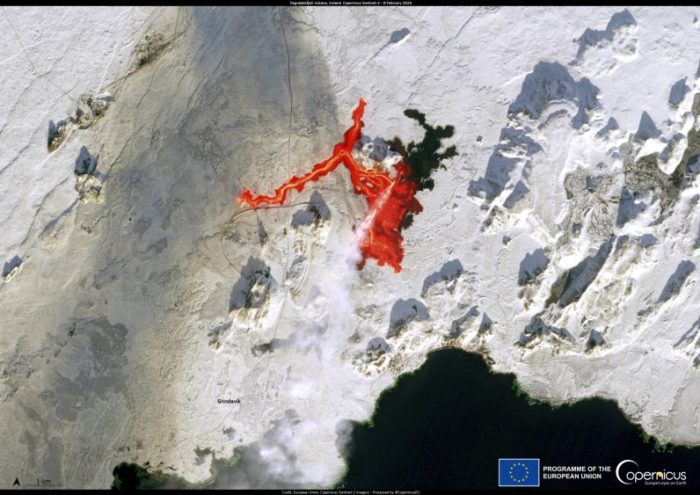
Iceland experienced a volcanic eruption in March 2021, marking the beginning of a period of heightened volcanic activity. This eruption, located in the Reykjanes Peninsula, southwest of Reykjavik, captivated the world with its stunning displays of fiery lava flows.
Eruption Details
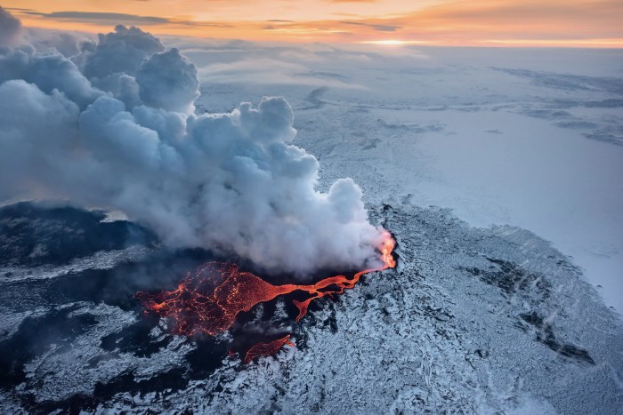
The eruption, categorized as a fissure eruption, began on March 19, 2021, near the Fagradalsfjall mountain. It was characterized by the gradual opening of a fissure, releasing lava that flowed across the surrounding landscape. The eruption lasted for six months, concluding in September 2021.
Impact on the Environment and Infrastructure
The eruption’s impact on the surrounding environment was significant. The lava flows, reaching temperatures of over 1,000 degrees Celsius, transformed the landscape, covering vast areas with solidified lava. The eruption also released gases, including sulfur dioxide, into the atmosphere, potentially affecting air quality.
The eruption had a minimal impact on infrastructure. While the eruption site was located near a major road, authorities were able to reroute traffic effectively, ensuring minimal disruption. The eruption also posed no immediate threat to nearby towns or settlements.
Response and Preparedness Measures
Icelandic authorities responded swiftly and effectively to the eruption. The Icelandic Meteorological Office (IMO) closely monitored the eruption’s progress, providing regular updates to the public. The Civil Protection Department implemented evacuation measures in the immediate vicinity of the eruption site, ensuring the safety of residents.The eruption highlighted the importance of preparedness and rapid response in dealing with volcanic events.
Iceland, with its history of volcanic activity, has a well-established system for monitoring and responding to eruptions. The authorities’ swift actions and effective communication ensured minimal disruption and safe management of the eruption.
Technological Advancements in Volcanic Prediction

Volcanic eruptions are powerful natural phenomena that can pose significant threats to human life and infrastructure. While predicting volcanic eruptions with absolute certainty is still a challenge, technological advancements have significantly improved our ability to monitor and forecast these events.
These advancements provide valuable insights into volcanic activity, enabling scientists to better understand the processes leading to eruptions and issue timely warnings to mitigate potential risks.
Remote Sensing
Remote sensing technologies play a crucial role in monitoring volcanoes from afar. These technologies use various sensors and instruments to collect data about volcanic activity without requiring direct physical contact.
- Satellite imageryprovides valuable information about volcanic activity, including changes in surface temperature, gas emissions, and ground deformation. For example, satellites equipped with thermal infrared sensors can detect changes in surface temperature associated with rising magma or hydrothermal activity. These observations can help scientists identify potential eruption hazards and monitor the evolution of volcanic unrest.
- Synthetic Aperture Radar (SAR)is another valuable remote sensing technique used to monitor ground deformation. SAR uses radar waves to create detailed images of the Earth’s surface, revealing subtle changes in ground elevation or movement. This data can be used to track the inflation or deflation of volcanoes, indicating the movement of magma beneath the surface.
Expand your understanding about year ar glasses what to expect with the sources we offer.
The 2014-2015 eruption of Mount Kilauea in Hawaii was successfully predicted using SAR data that detected significant ground deformation prior to the eruption.
Seismic Monitoring
Seismic monitoring is a fundamental tool in volcanic prediction. Earthquakes are often associated with volcanic activity, providing crucial clues about the movement of magma beneath the surface.
- Seismometersare instruments deployed around volcanoes to detect and record seismic waves. The frequency, intensity, and location of these seismic signals can provide valuable information about the location, depth, and magnitude of magma movement. For example, an increase in the frequency and intensity of seismic activity, particularly in the form of “harmonic tremors,” can indicate the upward movement of magma towards the surface, potentially leading to an eruption.
- Seismic networksare used to monitor volcanic activity over larger areas. These networks consist of multiple seismometers strategically placed around a volcano or volcanic region. The data collected by these networks allows scientists to triangulate the location of seismic events and understand the spatial distribution of volcanic unrest.
The success of the Icelandic Meteorological Office (IMO) in predicting the 2021 eruption of Fagradalsfjall volcano was largely attributed to the comprehensive seismic monitoring network deployed around the volcano.
Gas Analysis
Volcanic gases provide valuable insights into the state of a volcano and its potential for eruption. Changes in the composition and abundance of gases can indicate the presence of magma at shallow depths and the potential for an eruption.
- Gas sensorsare deployed near volcanic vents or craters to measure the composition and concentration of gases released by the volcano. These sensors can detect gases like sulfur dioxide (SO2), carbon dioxide (CO2), and hydrogen sulfide (H2S), which are often associated with volcanic activity.
For example, an increase in SO2 emissions can indicate the ascent of magma towards the surface.
- Remote sensing techniques, such as satellite-based spectroscopy, can be used to measure gas emissions from volcanoes over large areas. These techniques allow scientists to monitor the overall gas flux from a volcano, providing valuable information about the state of the volcanic system.
Predictive Modeling for the Next Eruption
Predictive modeling plays a crucial role in forecasting volcanic eruptions, helping scientists understand the complex processes leading to these events. These models analyze various data points to predict the likelihood, timing, and intensity of eruptions, providing valuable insights for hazard mitigation and preparedness.
Factors Influencing Model Accuracy and Limitations
The accuracy of predictive models relies heavily on the quality and quantity of data used. Factors that influence the accuracy and limitations of these models include:
- Data Availability and Quality:Comprehensive and reliable data is essential for accurate predictions. This includes historical eruption records, ground deformation measurements, gas emissions, seismic activity, and other geophysical data. The availability and quality of these data can vary significantly between volcanoes and regions, impacting model accuracy.
- Volcanic Complexity:Volcanoes are complex systems with diverse behaviors and unique characteristics. Each volcano has its own eruption history, magma chamber dynamics, and geological setting, which influence the effectiveness of predictive models. Generalizing models across different volcanoes can be challenging due to their inherent variability.
- Model Assumptions and Simplifications:Predictive models often rely on simplifying assumptions about volcanic processes to make them computationally feasible. These assumptions can introduce uncertainties and limitations in the model’s ability to capture the full complexity of volcanic behavior.
- Data Integration and Interpretation:Combining data from various sources, including ground-based observations, satellite imagery, and remote sensing, is crucial for comprehensive analysis. However, integrating and interpreting these diverse data sets can be challenging, potentially leading to inconsistencies or biases in model predictions.
Data Integration for Predictive Modeling
Predictive models integrate data from various sources to provide a comprehensive understanding of volcanic activity. This data integration allows for a more accurate and nuanced assessment of eruption likelihood and potential impacts:
- Geodetic Data:Ground deformation measurements, obtained through techniques like GPS and InSAR, provide insights into magma movement and pressure changes within the volcano. These data are essential for detecting pre-eruptive inflation or deflation, which can indicate an impending eruption.
- Seismic Data:Seismic monitoring networks detect earthquakes associated with magma movement and volcanic unrest. Analyzing the frequency, magnitude, and location of these earthquakes helps identify areas of potential eruption and assess the intensity of volcanic activity.
- Gas Emissions:Monitoring gas emissions, such as sulfur dioxide (SO2) and carbon dioxide (CO2), provides information about the composition and activity of the magma beneath the volcano. Increased gas emissions can indicate magma rising towards the surface, suggesting a potential eruption.
- Thermal Data:Satellite imagery and thermal sensors detect changes in surface temperature, indicating heat anomalies associated with volcanic activity. These data can help identify areas of increased heat flow or potential eruption sites.
- Historical Data:Analyzing historical eruption records, including eruption frequency, magnitude, and style, provides valuable insights into the long-term behavior of a volcano. This data helps establish baselines for current activity and identify potential eruption patterns.
Examples of Predictive Modeling in Volcanic Eruptions
Predictive models have been successfully applied to various volcanic eruptions, providing valuable insights for hazard mitigation and preparedness.
“The eruption of Mount St. Helens in 1980 was preceded by a series of earthquakes, ground deformation, and gas emissions, which were effectively monitored and analyzed using predictive models. This allowed for the evacuation of nearby communities and the timely implementation of mitigation measures, significantly reducing the impact of the eruption.”
“The 2010 eruption of Eyjafjallajökull in Iceland was also effectively predicted using a combination of geodetic, seismic, and gas emission data. The models accurately forecasted the timing and intensity of the eruption, enabling authorities to prepare for the event and minimize disruption to air travel.”
The Role of Technology in Mitigation and Response

Technology plays a crucial role in mitigating the impact of volcanic eruptions and ensuring the safety of communities. It allows us to better predict eruptions, monitor volcanic activity, and communicate warnings effectively.
Communication Technologies for Warning Systems and Evacuation Plans
Effective communication is vital for warning systems and evacuation plans during volcanic eruptions. Technology provides various tools to disseminate information rapidly and efficiently.
- Early Warning Systems:Modern monitoring systems use sensors to detect changes in volcanic activity, such as ground deformation, gas emissions, and seismic activity. This data is transmitted in real-time to alert authorities and communities of potential eruptions.
- Mobile Phone Alerts:Text messages and mobile apps can be used to quickly notify residents of volcanic activity and evacuation orders. This ensures that even those without access to traditional media can receive critical information.
- Social Media Platforms:Social media platforms can be used to share information about volcanic activity, evacuation routes, and safety guidelines. They also provide a platform for real-time updates and communication between authorities and the public.
Assessing and Managing Volcanic Hazards
Technology enables us to assess and manage volcanic hazards effectively, reducing the risk of damage and loss of life.
- Remote Sensing:Satellites and drones equipped with cameras and sensors can monitor volcanic activity from afar. They provide valuable data on volcanic gas emissions, thermal anomalies, and changes in the landscape.
- Geographic Information Systems (GIS):GIS software allows scientists to analyze and visualize data from various sources, including remote sensing, ground-based monitoring, and historical records. This helps them understand volcanic hazards and develop mitigation strategies.
- Modeling and Simulation:Computer models can simulate volcanic eruptions and their potential impacts. These models help scientists predict ash dispersal, lava flow paths, and the effects of volcanic gases.
Future Research and Development: Iceland Eruption How Tech Can Help Predict The Next Volcanic Event
The recent eruption in Iceland has underscored the critical need for continued research and development in volcanic prediction and mitigation. Advancements in technology, particularly in the field of artificial intelligence, hold immense potential to improve our understanding of volcanic processes and enhance our ability to respond effectively to future eruptions.
The Potential of Artificial Intelligence
Artificial intelligence (AI) is revolutionizing many fields, and volcanology is no exception. AI algorithms can analyze vast amounts of data from various sources, including seismic activity, ground deformation, gas emissions, and satellite imagery. This capability allows for the identification of subtle patterns and anomalies that might otherwise go unnoticed, providing valuable insights into volcanic behavior.
- Predictive Modeling:AI can be used to develop sophisticated predictive models that can forecast the timing, intensity, and potential impact of volcanic eruptions. These models can incorporate data from multiple sources and learn from past eruptions to improve accuracy and reliability.
For example, AI models can analyze historical data from Mount Vesuvius to predict the likelihood of future eruptions and their potential impact on surrounding communities.
- Early Warning Systems:AI-powered early warning systems can provide real-time alerts to authorities and the public about potential volcanic activity. These systems can use data from seismic sensors, gas detectors, and other monitoring equipment to detect changes in volcanic behavior and issue timely warnings.
This can allow for the evacuation of populations at risk and the implementation of mitigation measures, reducing the potential for casualties and damage.
- Risk Assessment:AI can be used to assess the risks associated with volcanic eruptions, including the potential for ashfall, lava flows, and gas emissions. These assessments can help authorities prioritize mitigation efforts and allocate resources effectively. For example, AI models can analyze the potential impact of ashfall from a hypothetical eruption of Mount Etna on air traffic and infrastructure.


